

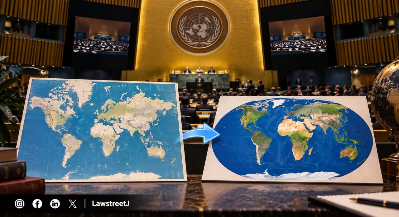
NEW YORK - The United Nations General Assembly voted 164 to 1, with six abstentions, to adopt a resolution encouraging member states, international bodies, technology companies and educational institutions to move away from the 450-year-old Mercator map projection in favour of the Equal Earth projection, which more accurately represents the relative size of continents, particularly Africa. The United States cast the sole vote against the resolution.
The Vote and What the Resolution Actually Requires

The resolution, titled the "Correct the Map" initiative, was formally introduced by Togo on behalf of African Union member states, with additional co-sponsorship from the Bahamas. It passed with overwhelming support: 164 countries voted in favour, only the United States voted against, and six countries, Estonia, Georgia, Lithuania, Moldova, Serbia and Ukraine abstained. The resolution calls on UN member states, international organisations, educational institutions, publishers and technology companies to adopt equal-area map projections, principally the Equal Earth projection, in place of the Mercator projection wherever the accurate relative size of countries and continents matters, such as in classroom teaching materials, official publications and digital mapping platforms.
Importantly, the resolution is non-binding under international law. It does not compel any country, company or institution to change its maps, and it carries no enforcement mechanism. The text explicitly carves out an exception for navigation, stating that it "in no way challenges the use of the Mercator projection for maritime and aerial navigation, for which it remains fully suited," according to a statement issued by Togo's foreign ministry. This distinction matters because the Mercator projection, despite its size distortions, remains genuinely useful for sailors and pilots: a straight line drawn anywhere on a Mercator map represents a constant compass bearing, a property called "rhumb line" navigation that made the projection indispensable to European sailors for centuries and that no replacement projection has managed to replicate as simply.
Why the Mercator Projection Distorts the World and by How Much

The Mercator projection was created in 1569 by Flemish cartographer and geographer Gerardus Mercator specifically to aid maritime navigation during the Age of Exploration. Its core mathematical trade-off is that it stretches landmasses increasingly as they move away from the equator toward the poles, meaning countries and continents closer to the equator appear artificially smaller relative to those in higher latitudes. The distortion is not marginal, it is dramatic. On a standard Mercator map, Greenland appears roughly comparable in size to the entire African continent. In reality, Africa is approximately 14 times larger than Greenland, large enough that the United States, China, India, Japan and most of Western Europe could all fit within its borders combined, with room to spare.
This distortion is precisely what campaigners behind the resolution set out to correct. The Equal Earth projection, the alternative promoted in the resolution, was developed only in 2018 by a team of cartographers, and it is specifically designed as an equal-area projection, meaning it preserves the accurate relative size of landmasses across the globe, even though it necessarily sacrifices some of the angular and directional accuracy that made Mercator useful for navigation in the first place. No single map projection can perfectly preserve both shape and size simultaneously, which is why the choice of projection has never been a purely neutral or technical decision, it always involves a trade-off, and campaigners argue that centuries of relying on Mercator by default has quietly shaped how generations of students and policymakers perceive the relative importance and scale of different parts of the world.
The Campaign Behind the Resolution and the Reaction From the US and Ukraine
The push to change the world's default map traces back to a campaign led by two African advocacy organisations, Africa No Filter and Speak Up Africa, which argued that the Mercator projection's visual shrinking of Africa has had a real and lasting effect on how the continent is perceived globally, in media coverage, in policy discussions and in educational settings. Moky Makura, executive director of Africa No Filter, described the existing map's distortion as effectively "the world's longest misinformation and disinformation campaign," a framing the African Union, representing all 55 African Union member states, formally adopted when it endorsed the campaign, describing accurate map representation as a matter of what organisers termed "cognitive justice."
The United States was the only country to vote against the resolution. Speaking on behalf of the US delegation, Mike Waltz criticised the General Assembly for devoting time and resources to what he described as "map projects from the 16th century and their role in promoting reparations and cognitive justice," rather than focusing on matters more directly tied to international peace and security, adding that resolutions of this kind amounted to "barnacles" on the UN's core work.
Ukraine's abstention stemmed from an entirely separate and unrelated concern. Ukraine's UN envoy, Andriy Melnyk, said Kyiv could not support the resolution in its current form because certain Equal Earth-based maps associated with the broader campaign depict Crimea and other Ukrainian territories currently under Russian occupation in a manner Ukraine considers inconsistent with its internationally recognised borders and with previous UN resolutions affirming Ukrainian territorial integrity following Russia's 2014 annexation of Crimea. The other five abstaining nations, Estonia, Georgia, Lithuania, Moldova and Serbia, did not offer as detailed a public explanation for their position, though several of these countries have their own long-standing sensitivities around territorial mapping and border representation.
Early Signs of Adoption Beyond the UN Vote
Even though the resolution carries no binding force, some institutions had already begun shifting away from Mercator before the vote itself, and the UN's endorsement is likely to accelerate that trend. A World Bank spokesperson confirmed the institution already uses the Winkel-Tripel or Equal Earth projections for its static published maps and is in the process of phasing out Mercator on its web-based interactive mapping tools as well. Google Maps had already moved away from a flat Mercator display toward a 3D globe view on its desktop version back in 2018, although the Mercator projection remains the default view on Google Maps' mobile application, meaning most everyday users navigating on their phones still encounter the distorted projection daily.
Beyond the tech sector, France's Foreign Minister Jean-Noël Barrot separately announced that the French foreign ministry would abandon the Mercator projection in official use, adopting maps described as "more faithful to actual surface areas," a decision he said followed recommendations from cartographers and scientists consulted by the ministry. Campaigners behind the "Correct the Map" initiative have indicated that education is their next major target: Speak Up Africa co-founder Fara Ndiaye said the organisation is "actively working on promoting a curriculum where the Equal Earth projection will be the main standard across all African classrooms," signalling that the campaign's ambitions extend well beyond a single UN resolution toward reshaping how an entire generation of students first learns to picture the world.
Because UN General Assembly resolutions of this nature are advisory rather than legally enforceable, the practical impact of Friday's vote will depend entirely on whether individual governments, publishers, technology companies and educational systems choose to act on it. For now, the Mercator projection remains the map most people around the world encounter by default, particularly on mobile navigation apps, even as the vote marks the most significant international institutional endorsement yet for an alternative that shows the world, and Africa in particular, closer to its true size.